BEFORE THE CROSSING - ORDER OF EVENTS
1. They left Egypt: It has been commonly assumed that the sea crossing was in the Gulf of Suez. But if this were so, the Hebrews would still be on Egyptian soil as they faced the Red Sea crossing. Egypt borders the entire western shore of the Gulf of Suez. Wherever they camped along that coast, they would still be in Egypt.
However, the book of Exodus tells us that before they came to the Red Sea crossing, they had ALREADY LEFT Egypt. The "children of Israel went up harnessed OUT OF the land of Egypt." (Ex.13:18) So, when they later arrived at the Red Sea and found themselves trapped, they complained to Moses, their leader: "Because there were no graves in Egypt, have you taken us away to die in the wilderness?" They asked why Moses had carried them forth "OUT OF Egypt?...we did tell thee IN Egypt, saying, Let us alone." (Ex.14:10-12). You'll notice, this wilderness was not "in Egypt".
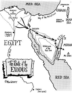
2. They travelled along the southern highway: From their homes in the Nile Delta (the region known as Rameses, or Goshen), the Hebrews had first assembled at Succoth, a military station on the eastern border of Egypt. Here they were "harnessed", or placed in ranks (Ex. 13:18).
From here, there were 2 highways to Canaan:
Route A - "the way of the Philistines" the shorter route (v.17)
Route B - "the way of the Red Sea" - the southern route (v.18)
They took the southern (and longer) route. Josephus, the Jewish historian, concurs that the Hebrews headed southward from Egypt.
3. Then through the desert: This southern route took them by the wilderness of the Red Sea - the area between the 2 arms of the Red Sea.
4. Turned off the highway: Next, they were instructed to "turn" and encamp by the sea (Ex.14:2).
Leaving the highway, the Hebrews turned aside - through the Wadi Watir, a wide and wild mountain gorge, a natural roadway from Egypt. They were "entangled in the land" (v.3), travelling through an area with mountains all around, which seemed to hem them in.
5. Camped "by the sea": It led them in one direction - to an enormous size beach. At this beach, they found themselves "shut in" (v.3).
THE CROSSING ITSELF
1. A suitably large camping area: With 600,000 men (Ex.12:37), plus women and children, there must have been at least 2 million people on this march.
The Wadi Watir leads to a wide expanse of beach on the Gulf of Aqaba which could easily have held the multitude, their flocks and also Pharaoh's pursuing army - separating the 2 groups by several kilometres. This beach at Nuweiba is so large (7 km by 3 km), it can easily be seen on satellite maps. It is the only place that matches all the requirements of our checklist.
2. Closed in by mountains to the sea: At this point by the sea, the wilderness "shut them in " (Ex.14:3). Josephus adds that the Hebrews were shut up "between the inaccessible precipices and the sea; for there was (on each side) a ridge of mountains that terminated at the sea, which was impassible by reason of their roughness, and obstructed their flight... where (the ridges of) the mountains were closed with the sea." - Antiquities of the Jew, Book II,Ch. XV.
TOO FAR?
Question: Isn't this site too far from Egypt?
Wouldn't it have taken a long time to get there?
Answer: The distance from the Suez Canal to Nuweiba is 336 km (210 mls). In 1967, Moshe Dyan marched his troops from this very spot, Nuweiba, to Suez (near ancient Succoth) in just 6 days. And they camped at night.
The Hebrews did not stop and camp every night, as Moshe Dyan's troops did - they travelled both day and night:
"And the LORD went before them by day in a pillar of cloud, to lead them the way; and by night in a pillar of fire, to give them light; to go by day and night." (Ex.13:21)
With divine assistance, this huge mass of people travelled in an orderly manner both day and night, with great speed:
"Ye have seen what I did to the Egyptians, and how I bore you on eagles' wings."
The eagle is used to denote speed (e.g. 2 Sam.1:23 - "swifter than eagles"; Deut. 28:49 - "as the eagle flies"). We don't know precisely how long the journey took, but it was rapid.
TRAPPED!
Pharaoh's army entered from the same wadi, which is the only entrance on to the beach. This dry river gorge is located midway of the beach. Once the army entered the area, the Hebrews' only means of escape would have been to the south. But the mountains to the south extend all the way to the sea - they had no way of escape, or so it seemed.
HOW DEEP IS DEEP?
Question: How deep was this water over the crossing place?
Answer: If some people would only trust the Bible record - and take it literally - they could avoid later embarrasssment. The crossing place was not a shallow "sea of reeds", as commonly speculated. The Bible describes it thus:
dried the sea, the waters of the GREAT DEEP (Isa. 51:10)
a path in the MIGHTY WATERS (43:16,17)
led them through the DEEP (63:11-13).
British Admiralty charts show the Gulf of Aqaba arm of the Red Sea to be a 5,000 foot (1,600 metre) deep trench. That's positively "DEEP"!. The western shoreline drops steeply underwater into this "canyon" at a slope of 45 degrees. Our diving forays confirmed this fact.
However, at the precise location of the Nuweiba beach, the deep trench is spanned by an underwater land bridge. This pathway we have estimated at 900 metres in width. And from the Egyptian end, it slopes at a gentle angle of 6 degrees underwater - until widway across the sea it is some 1,000 feet (300 metres) below the surface of the sea. It then gently rises to the opposite shore.
UPDATE:
What the new data DOES show is a swatch of sea floor from Nuweiba across to the Saudi shore, which is about 300 to 320 feet deep at the deepest point. This swatch of sea floor is roughly between 7 and 10 miles wide. On either side, large cracks in the earth extend down to almost 3,000 feet to the north, and 5,000 to the south. This new information is quite exciting, because it shows a consistent pathway across the gulf to the other shore that, with the water removed, could have easily been traveled. When the digital data was fed to a topographical mapping program, it revealed a 3-D model of the sea floor in the Gulf. Because a 300 foot depth would not show up at all on a map covering this large number of square miles, it has been enhanced to exaggerate the features for purposes of demonstration. The depths are in ratio. That digital model can be seen below.
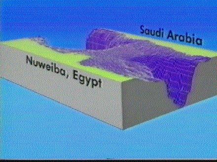
This bridge was formed by washouts meeting each other from 2 directions - from the western & eastern shores. I cannot shake off the feeling that in the closing stages of the Great Flood, God in His foreknowledge, divided the Gulf with this path across the sea, for the event He saw ahead.
Interestingly, Scripture alludes to this, with the Creator making a "path in the mighty waters" (Isa.43:16,17), a "path in the great waters" (Psa.77:19,20), "dividing the water" (Isa.63:12) of this deep trench.
HOW LONG TO CROSS?
Objection:Rabbi Sherwin Wine, founder of Humanistic Judaism, claimed on T.V. that the event never happened. "It would have taken them weeks to cross," he sneered. Answer:Easy to say. But it does not take much effort to discover that this man forgot to sit down and do his arithmetic: * Width of underwater bridge: 900 metres. (But let's be cautions and say that only 750 metres/2,500 feet of this width was used.) * Allowing 5 feet (1,5 metres) per person side to side, would give space for 500 persons abreast. * With the length of the crossing at 8 miles (13 km), and travelling at 2,5 miles (4 km) per hour, it would take 3 ( hours for the front row of persons to cross over. * With 500 persons abreast, and a total of, say, 2 million people, there would be queues 4,000 deep. * Allow a distance of 5 feet (1,5 metres) from person to person, one behind the other. Also allow for half of these persons to be driving an animal (at an extra 10 feet/ 3 metres average space for each animal). Allow also for a quarter of the people in possession of a cart (occupying a further feet/3 meters for each vehicle). All this would require a procession 9.6 miles/15.4 km in length. * Thus the final row of persons would be 9.6 miles/15.4 km, or 4 hours' walking time behind the front row. * The final row would leave the western shore some 4 hours after the departure of the front row, and would take 3 ( hours to make the crossing. * RESULT: Total crossing time for 2 million people, plus animals and carts, would be 7 ( hours. Even if these figures require some adjustment, it is still safe to say that the time needed to make the crossing was by no means excessive.
PHARAOH'S ARMY DROWNED
Then the cloud separating the Hebrews from their pursuers was removed, and the Egyptians saw their quarry escaping. They went down on to the sea bed after them - 600 chariots and 251,000 men (Josephus). Then with a heart-chilling roar, the 2 walls of frozen water (which we may assume had been thawing and thinning since the wind dropped) suddenly collapsed upon them. "The waters covered the chariots." (Ex.14:28) The monarch and the nation's army were in that place of fearful danger destroyed themselves!
CHARIOT PARTS FOUND ON THE SEA BED
Chariots and separated wheels from the Egyptian "Thut-MOSES" dynasty period. Human and horse skeletal remains. And an ancient monument which matches another directly across the sea, alluding to the event.
THE ONLY CONCLUSIONS WE CAN COME TO IS THAT THIS IS THE TRUE CROSSING POINT OF THE EXODUS!
Neweiba - the site where the Israelites crossed the Red Sea.